|
KNMI for the Caribbean Netherlands
Volcanoes in the Dutch Caribbean
Monitoring.
To ensure adequate and timely warning for the 5200 inhabitants of the islands in case of volcanic activity, Mount Scenery and The Quill should be monitored continuously. Magma intrusions and eruptions are usually preceded or accompanied by measurable signals, such as increased seismicity and/or surface deformation. Continuous (real-time) monitoring can help detect such precursory activity and thus aid in the mitigation of volcanic risk.
To identify volcanic unrest, it is essential to understand the base-line of activity. This means a volcano monitoring network should be installed and operational before the onset of activity, thus to be able to observe deviations from "normal". It should be noted that each volcano exhibits its own characteristics; what is "normal" for one volcano could be a clear sign of "unrest" for another. It is therefore also essential to learn to understand the characteristics of the volcano which is being monitored. This can only be done by monitoring the volcano for a prolonged period.

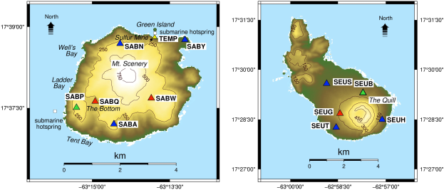
The geophysical monitoring network of the Royal Netherlands Meteorological Institute (KNMI) at Saba (left) and St. Eustatius (right): permanent sites with colocated seismometer and GNSS sensor (blue triangles), seismometer sites (red triangles), submarine hotsprings (white squares), and a temporary site with two temperature sensors (yellow triangle). The green triangle indicates a planned, new location in our monitoring network.
KNMI operates a monitoring network on the islands of Saba and St Eustatius which consists of
- Seismometers, which record Earth vibrations (ground velocity)
- Global Navigation Satellite System (GNSS) stations, which record Earth displacements (surface deformation)
- A temperature sensor.
Seismic unrest is commonly observed before the onset of an eruption because magma movement usually generates some form of seismic energy, either by breaking the rock it passes through (earthquakes) or by the flow of the fluid or gas through existing cracks (earthquakes, tremor).
The current Netherlands Antilles (NA) seismic network consists of 11 broadband seismometers: 5 on Saba (SABA, SABN, SABQ, SABW and SABY), 5 on St. Eustatius (SEUS, SEUH, SEUG, SEUT and SEUB) and 1 on St. Maarten (SMRT).
Magma accumulation and migration, which usually occur before the onset of an eruption, often cause ground deformation. One way to observe these displacements in near real-time is by using GNSS stations, which consist of permanently installed receivers and antennas which track surface motion over time.
Currently 8 continuous GNSS instruments are operating in the Caribbean Netherlands: 4 on Saba (SABA, SABN, SABY and SABP) and 4 on St. Eustatius (SEUT, SEUH, SEUS and SEUB).
 |
|
 |
GNSS station at St. Eustatius, The Quill in the background. |
|
GNSS station on Saba, Mount Scenery in the background |
Hotspring monitoring at volcanoes can detect changes in the temperature and chemistry of the spring-parameters that can vary due to moving magma. When magma decompresses as it rises towards the surface, volcanic gas escapes. Volcanic gas thus precedes the arrival of magma at the surface and is often the first sign of pending unrest.
|
